


SUMO GeoSurveys is one of the UK’s leading drone providers for archaeological and heritage projects. Our experienced team have you covered from small-scale excavations to large-scale earthwork surveys; building recording to detailed Illustrations; volumetric reports of spoil heaps to GIS analysis and interpretations.
Our range of techniques and skills are effective at all stages of historical projects, offering a thorough recording package, carried out efficiently and cost-effectively.

Above : Aerial photo from a Building Recording survey.
SUMO GeoSurveys in Archaeology and Heritage
SUMO is well established in the historic landscape sector, with decades of experience in Geophysical and Aerial Surveying. Featuring on the likes of Time Team, Digging For Britain and in countless magazines, SUMO is a staple of archaeological recording in the UK.
Our concise methodologies, often combining Geophysical and Aerial Surveys, amount to a thorough account of a site’s history. We are increasingly using RGB and Multispectral Drone Surveys to target areas for Geophysics, or even surveying an entire site with both aerial and ground techniques to paint a full picture of archaeological features.
This two-pronged approach can greatly reduce the need for invasive methods, such as trial trenching, both preserving the underlying archaeology as well as saving substantial costs in the long run.
Multispectral Drone Surveys can also serve as an alternative to Geophysics when access is limited or prohibited, particularly when the crops are high.

Above : Combined UAS RGB and Multispectral, and Geophysical (Magnetometry) interpretations.
Digital Drone Deliverables
The versatility of drone surveying equates to a range of utilities and outputs which will contribute to your project, be it part of a planning application, historical assessment, restoration project, or research dig.
Orthophotos

Above : Orthophoto (landscape and earthwork recording).
Drone-based photogrammetry can produce high-resolution orthophotos of sites, ranging from small excavations up to expansive landscapes spanning hundreds of hectares. The same approach can be applied to any site, whether it’s rural or urban.
Using ground control targets and GPS, the orthophoto will be georeferenced to OS coordinates with an error of <5cm (though generally between 1 and 3cm), therefore scaled and projected accurately for use in GIS.
This high level of mapping provides a visual record of a site’s location, condition, and features, and is a much quicker and, therefore, cheaper method than terrestrial surveying.
Digital Elevation Models (DEMs)
![Digital Elevation Model [DEM] for GIS analysis.](https://static.wixstatic.com/media/eb7905_b7f3bebddae74313a83e09d85eaa99fc~mv2.png/v1/fill/w_980,h_550,al_c,q_90,usm_0.66_1.00_0.01,enc_avif,quality_auto/Screenshot%202025-05-13%20at%2012_33_49.png)
Above : Digital Elevation Model [DEM] for GIS analysis.
Digital Elevation Models (DEMs) contain X,Y,Z data across a site and present the gradients according to a colour palette. The DEM can be analysed and manipulated in GIS software to tease out topographic and micro-topographic features which may relate to archaeology. Consequently, the DEM serves as the basis to our interpretive reports.
Multispectral

Above : Multispectral surveys for sub-surface investigations.
Multispectral Surveys have the capacity to detect sub-surface features with archaeological potential. This method uses a camera array equipped with multiple sensors to acquire data invisible to the human eye across the electromagnetic spectrum. When sub-surface features impact the overlying ground, they may be detected following a Multispectral Survey.
This technique can be used as an alternative to geophysics when physical access is prohibited or restricted, for example due to crops. Alternatively, it can be employed to support geophysics.
RGB photogrammetry is carried out simultaneously, providing both datasets and informing an interpretive report.
Excavation Recording

Above : Excavation recording (pre-, mid- & post-ex surveying for ongoing progress monitoring).
Drone photogrammetry can be conducted throughout the lifetime of an archaeological excavation, providing ongoing records at each stage. This method is far quicker and accurate than manually recording each feature with a GPS or hand-drawn plan.
Orthophotos and DEMs are georeferenced to OS coordinates, meaning that these outputs can be dropped into position in GIS for measurements, digitization, and analysis.
General site photos and video can further convey the progress of an excavation and serve as marketing material.
Multiple visits to a site can be booked in advance at a discounted price.
Historic Building Models

Above : 3D model of a castle, created using drone photogrammetry.
Drone photogrammetry can be employed to create 3D models of buildings and structures, creating a digital record of the subject. The use of a drone means that the whole building can be recorded safely from the ground without the need for manually accessing higher areas.
From the model, high-resolution orthographic elevations can be produced and serve as a basis for Line Drawings and Stone-by-Stone Illustrations. These outputs can be used by architects, historians and masons as part of a restoration project, Historic Building Recording, or shared for marketing and publicity.
Where greater accuracy is required, the photogrammetry can be combined with a terrestrial Laser Scan Survey for improved scaling and projections.

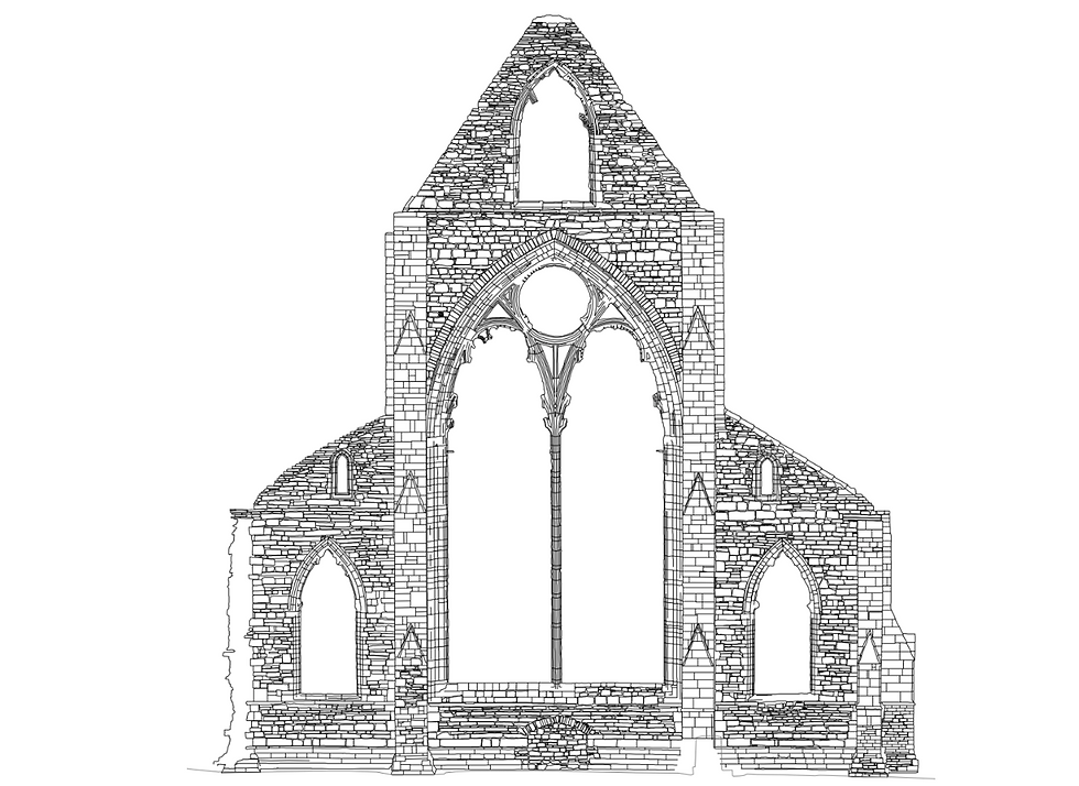
Above left : Orthographic elevation for historic building recording. Above right : Line drawing.
Above : High detail Stone-by-Stone Illustration.
GIS Analysis and Interpretive Reports

Above : Interpretive Report.
Drone surveys amount to only half of what SUMO’s geospatial department is capable of.
The real value of our work comes down to our reporting, including our highly detailed interpretive reports of Landscape/Earthwork Surveys. These reports include scaled figures following GIS analyses of the DEM and multispectral vegetation indexes (if applicable), an illustrated interpretation figure to highlight topographic and multispectral anomalies, and a concise but detailed discussion.
Other sources, such as available LiDAR or HER accounts, may be included, and recommendations for future work may also be added.
Historic Building Recording

Above : Phase Plan for Level 2 Building Recording.
Similarly, we can produce Level 1 and Level 2 Historic Building Recording reports. We favour using photogrammetry to model the building, and produce orthophotos from which measurements can be obtained and a phase plan drawn up. Alternatively, we can capture the images and carry out photogrammetry to feed into your own reports, if required.
Volumetric Calculations


Above : Volumetric Report.
Volumetric surveys carried out by drones are a safe, cost-effective and efficient way of measuring spoil heaps and excavations, to aid the planning and management of a project. This information can be extracted following a photogrammetry survey of a site of spoil heap.
Setting Surveys
By their nature, drones offer an unparalleled perspective of historical buildings, structures and landscapes, and are therefore the ultimate tool for Setting Surveys.
General photos and video, photogrammetry (where applicable) and panoramic spheres, can perfectly showcase an historic asset within its wider context.
Archaeological Survey FAQ's


Aerial Surveys

Aerial
Survey

Landscape
Survey

Thermal
Surveys

Aerial Topographic
Surveys

Multispectral Survey

Volumetric
Surveys

Archaeological Survey

Renewable
Survey

Water Leak Detection

Asset
Inspection

Roof
Inspection

Building
Recording

School
Surveys

Internal Photogrammetry
