Topographic Surveys: 101
- Sep 18, 2018
- 3 min read
Updated: Jan 31, 2024
Topographic surveys are a must-have for any professional who needs a record of the physical features of their site.
Whether its 1000 acres of land or simply your back garden; SUMO’s Senior Surveyor Patrick Cullity talks through the basics of topography. We look into how it can apply to a variety of sites.

What is Topography?
The Oxford English Dictionary definition of the word topography (often referred to as ‘topo’ within the survey industry) is the arrangement of the natural and artificial physical features of an area.
A topographic survey records a mapped representation of the physical features of an area. Typical features that are mapped include:
road features,
buildings,
walls, fences,
street furniture,
surface utility covers,
trees and vegetation (the list is endless).
What is the process?
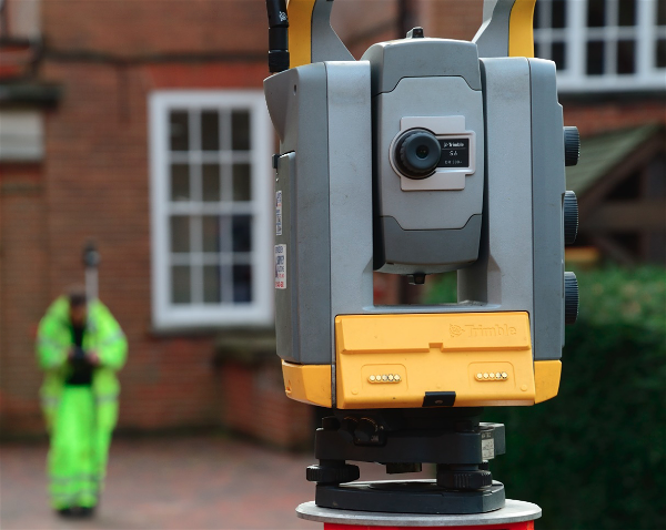
Topographic surveys are completed using a total station and topographic pole. The total station is positioned within the survey area. Then the Surveyor records various physical features using a topographic pole. Each of these recordings is referred to as a ‘survey point’.

Above left: Topographic total station Right: Topographic pole.
Every point surveyed is traced by the total station, which stores the data for post-processing. Each point is surveyed in 3D and the Eastings, Northings and Elevation are recorded.
Due to the data being collected in 3D the completed topographic survey can therefore be supplied in a 2D drawing or 3D model.
So, is all the equipment the same?
There is a great range of equipment available within the topographic survey industry. These are also new technological advances available as well.
Typically, for small to medium sized site areas, conventional total stations or GPS receivers are often used. They are the most appropriate equipment for the specific site area and size of the project. Although, on larger sites, digital aerial photogrammetry (UAV) may be used.
This can be much cheaper due to the speed of data collection over a larger scale area. As well as this, it cuts the ‘man-hours’ needed to survey sites of a larger scale, reducing costs further.
What equipment does SUMO use?
All our SUMO surveyors are identically equipped with the latest Trimble Robotic total stations and GPS surveying units, which utilise the VRS network. This is for referencing the surveys to the Ordnance Survey Grid and Level datum.
Example Survey drawing:


What are the applications of the technique?
The applications of the technique are endless. Referring back to the definition of a topographic survey, it is a mapped representation of the physical features of an area. This means that the technique (in theory) applies to any physical site. The limitations of the technique, which would disallow an area to be surveyed conventionally, are that the equipment must be able to function correctly within the space. As well as this, the surveyor must be able to safely survey the area. Even in these instances where a conventional topographic survey is not suitable, there is still the option for the use of Aerial Drones (UAV) to survey those hard to reach areas.
What are the benefits of having a Topographic Survey completed?
A topographic survey creates a mapped representation of the physical features of an area, which aids visualisation. Topographic models are used extensively in many sectors. This includes planning, design and construction in Civil Engineering projects, environmental projects and many more. In these cases, a full topographic drawing may prove essential to the smooth running of the project. The benefits of commissioning a full topographic survey will be seen throughout the life cycle of the project
SUMO prides itself on providing the best quality survey drawings in the industry. They provide fully colour-coded as standard and are available in hard and electronic copy.