Tripod-Mounted Scanning vs Mobile Scanning
- Jul 31, 2018
- 2 min read
Updated: Jan 31, 2024
In the last three years, there has been an explosion in the development and variety of hardware available for collecting laser scanned pointcloud data.
Scanning hardware is getting cheaper and faster. The choice range for data collection is vast and varied, depending on your needs. However, to use the most cost-effective method of data collection, clients need to engage with their surveyor and discuss what they are trying to achieve.

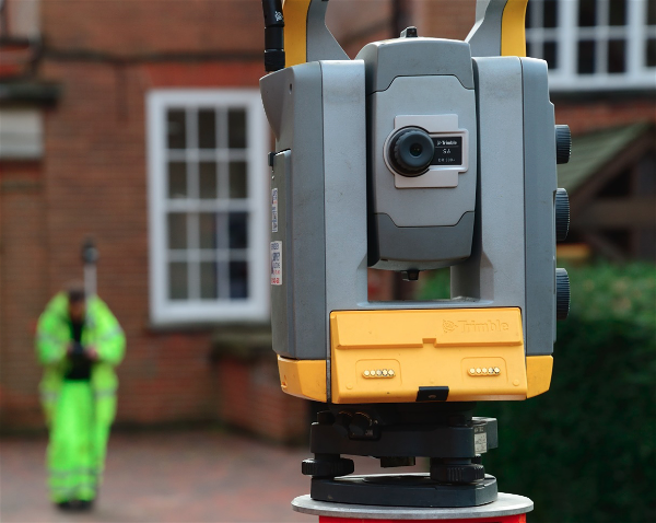
Above: FARO Focus
Lightweight tripod mounted scanners, like the FARO Focus have been the workhorse of many survey businesses. Also including mobile scanners like the more recent handheld GeoSLAM Revo. Accuracy, speed, capability and the end deliverable differentiate these two methods of data collection. These considerations should be discussed with your surveyor when deciding what approach to take.
So, what are the differences?
If you have commissioned a measured building survey in the last 5 years, the chances are that part or all of it has been collected by a FARO Focus tripod-mounted scanner. We own 5 of these scanners at SUMO. This type of scanner integrates easily with a control network of targets and can provide a level of accuracy equivalent to legacy 1:50 scale or +/-15mm across a building. They provide dense data which has a medium level of cleanness. The scanners also have an on-board colour camera. Newer models offer HDR imaging, though colour scanning takes additional time. Data collected this way can also be hosted on the internet and shared with our clients using FARO Webshare or Leica Truview. We expect to collect between 800 and 2,000m² in a day with this type of scanner.

Mobile scanning has been around for a long time. More recently has become cheap enough for mainstream applications. What makes it unique, is the speed of data collection. This can easily reach between 6,000 and 10,000m² of floor area in just one day. SUMO collected 250,000m² of data using the handheld GeoSLAM Revo last year across the UK school estate. The speed comes at a cost in other areas. Accuracy, density and cleanness of the pointcloud is lower than tripod mounted scanning and client delivery methods like web hosting are not available. Additionally, colour photography does not integrate well with mobile data. This method offers accuracy equivalent to 1:100 scale or +/-30mm across a building compared to 1:50 scale and +/-15mm with a tripod mounted laser scanner. However, the way mobile data is registered allows collection in ways not possible with tripod mounted scanners. This includes scanning ceiling voids through individually removed ceiling tiles.

Above: Example of mobile scanning data.

Above: Example of tripod-mounted scanning data
The two collection methods can also be used successfully together. For example, initially using mobile scanning to provide feasibility quality scan data across a whole site, followed by more detailed localised tripod mounted scanning in specific areas. Using tripod mounted scanning on the floor plate, combined with handheld scanning of ceiling voids is another example where the two methods complement each other.
The key to choosing the right method is to help your surveyor understand what you are trying to achieve. This will ensure that the data collected is suitable for the work to be done with it. SUMO is always happy to discuss the right way to collect the data you need in the most cost effective manner.