The use of Direct Reflex technology for topographic surveying…
- Nov 15, 2019
- 3 min read
Updated: Jan 31, 2024

Whether construction professionals are planning a small-scale extension or a substantial industrial redevelopment, having a clear understanding of a site area is crucial to the smooth running of a project. What’s more, should they proceed without that clear understanding, they may incur significant problems, including delayed time-scales and substantial additional costs.
There is however a solution, in the form of a comprehensive topographic (land) survey deliverable. Topographic survey data can be an essential component of a project, as the purpose of a land survey is to map all the relevant features on a site. This includes man-made, natural, on the ground, or above the surface features, together with the topography of the land itself.
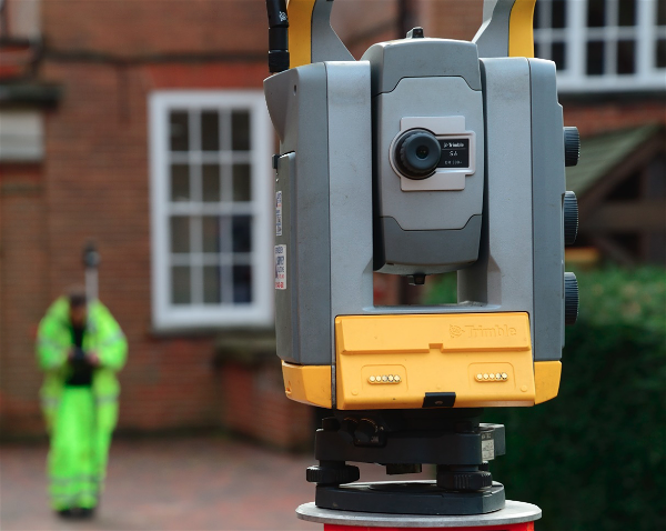
Surveyors, such as SUMO’s multi-skilled field-staff, use a variety of survey techniques and equipment to capture relevant features including laser scanning, real-time and dual-frequency GPS, and robotic instruments, plus of course the traditional method of recording points along site features using a survey pole held by a surveyor and a prism.
So, what happens if I want to develop a site, but there are elevated features which are, therefore, inaccessible to a surveyor?

Trimble's DR Plus™ range measurement technology provides an extended range of DR measurement without a prism to record measurements over exceptionally long-range distances, and hard to reach or unsafe survey points. SUMO surveyors are equipped with a variety of Trimble survey instruments, all with DR capabilities which enable them to capture remote details to millimetre accuracy.
The process of measuring remote features involves projecting a pulsed laser onto a surface and taking a measurement. As the infrared laser light reflects off the desired surface and returns to the instrument, calculations are made using either time of flight or phase shift technology to provide an accurate distance and to plot the X, Y and Z values instantly of the required target point.
The ability to conduct land surveys remotely means the surveyor can plot vital features accurately and quickly, without compromising safety in an attempt to physically reach elevated features.
What features can be surveyed using DR?

A full topographic survey includes the mapping of adjacent properties to a site, together with their associated Ridge and Eaves heights and by using DR, we do not need to access any private land. Knowing the height of neighbouring buildings can aid design professionals with regards to planning restrictions, loss of light difficulties and privacy considerations for new developments.
Historically, surveyors would need to take rounds of intersecting angles on the same target point followed by a calculation (either on-site or more likely back in the office) to produce ridge and eaves heights. So, the benefit of using DR is seen in the improved time efficiency and the ability to provide an instant visual result compared to older methods.
Although building heights are perhaps the primary feature surveyed using DR, it is certainly not the only one. Other benefits of using DR include the ability to survey tree heights, and electric and telegraph pole heights. The ability to measure such features is essential when, for instance, working on a solar farm project, in being able to show a client the areas of shadowing. Low branch heights can also be a crucial feature for many projects, as there can be potential clearance issues for plant manoeuvring to, from, and within a site area. The use of DR for measuring such features is clearly much more comfortable and safer than shimming up a tree trunk with a survey prism in hand!

Clearance heights are of obvious importance on many sites, and other site safety concerns such as low slung or sagging overhead power wires are also relevant. SUMO often experiences clients requesting the lowest sag point to be recorded on the survey, to give an idea of design height restrictions as well as mobility around a site.