


CASE STUDIES
Hampton Court Palace
The Hunt For Historic Remains At the Royal Palace. The Royal Palace of Hampton Court was built as the residence of Cardinal Wolsey in 1514. Prior to this, in 1494 the lands were leased to the royal courtier Giles Daubeney, who built a private house. This house was subsequently transformed in 1514 by Wolsey into a grand palace and his official residence. After his downfall, the palace was acquired by Henry VIII in 1529.

The Brief -
-
SUMO was commissioned to undertake a utility and an archaeological geophysics survey at Hampton Court Palace, in order to identify buried utilities and anomalies of archaeological origin.
-
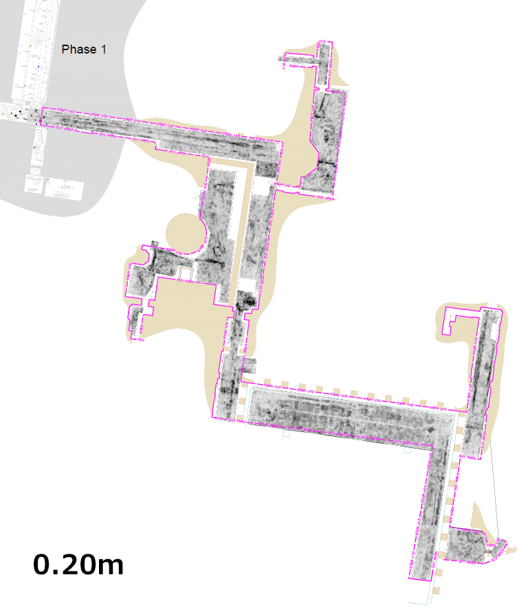
The surveys took place over two phases as shown in the plan below. The survey areas included the Cloisters, Round Kitchen, Chapel Court and Fountain Court.

SUMO was commissioned to survey two surveys area highlighted above in red (phase 1) and blue (phase2).
The Process -
-
The utility survey used both active and passive electro-magnetic location (EML) supplemented with a high-density array Ground Penetrating Radar (GPR). The results of the GPR survey were used to complement the EML survey in identifying buried utilities and to detect any archaeological remains within the survey area.
-
SUMO surveyed the site 'out-of-hours' to fit in with the public use of the building and surrounding areas during the daytime. The site survey was completed within two nights, with post-processing of the data taking place later.
The Results -
The utility survey at Hampton Court Palace identified many buried utilities. A number of these were confirmed by both the EML and the Ground Penetrating Radar survey, with additional utilities present only in the GPR data. A number of features were also identified at varying depths which could be associated with buried archaeology. However, some of these may be related to historic or abandoned services.
Animation of Ground Penetrating Radar data collected at Hampton Court Palace.
Notes on findings at the Round Kitchen:
Several linear and rectilinear anomalies were identified together with small complex responses in the eastern part of the Round Kitchen. These features are present at depths between 0.45m and 0.95m. They have been tentatively interpreted as being possible archaeology.


Notes on findings in the Fountain Court:
The survey identified rectilinear anomalies at the depth of 0.20m in the northern part of the Fountain Court. These features could also be associated with archaeology, but may also be the footprint of modern activity such as a stage construction. Further linear and complex responses were interpreted as possible archaeology remains. However, as before they might be an abandoned or historic section of utility services.

The Conclusion -
The survey successfully identified and mapped a significant number of buried utilities. The location of which had not been accurately recorded before, several previously unknown services were also located. These records will prove essential in planning any future works at the site. In addition, the survey identified several areas of potential archaeological interest which could also prove worthy of further investigation.
Survey techniques used in this case study...

Ground Penetrating Radar (GPR)
.png)
Electromagnetic Location (EML)


FREE SURVEY QUOTATION
Receive a FREE Survey quotation from one of our survey engineers?
Chat through any requirements you need, including site survey, survey methodologies and detail requirements.